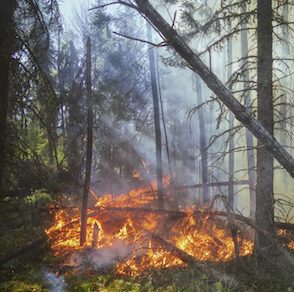
Yosemite’s towering trees are steeped in rich history and beloved deeply by the nation. But as wildfires continually threaten the area, these once revered trees have become a matchbox for the inferno that rages through the West. Fast moving fires in Mariposa County and Washburn have forced thousands to flee their homes, sometimes in the dead of night, as a large fire blooms behind them, consuming their homes.
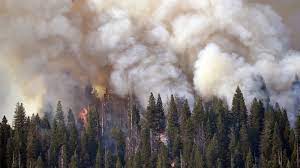
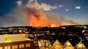
Fires in the West certainly aren’t a new topic, but the startling realization is that they grow increasingly devastating and vast every year. Yosemite is just one of many areas this summer that’s been ravaged by these infernos, with haunting images of dark orange and red skies emerging alongside the devastation, we get a glimpse into how these flames affect areas around the country.
Even if you live in an area far away from wildfire danger, you may have noticed hazy summer skies and an unusual orange tint especially around sunrise and sunset. There’s an explanation to this phenomenon, but it may not be one you want to hear. The simple answer is smoke. Smoke from a large wildfire can travel thousands of miles affecting everything in its path. So if you think you’re far enough away to not be affected, think again.
These orange and hazy skies are caused by wildfire smoke that carries ash. Ash reflects blue light, but allows yellow, orange and red light to pass through. While you may not be in danger of a fire, it’s still necessary to keep in mind that smoke exposure is unhealthy and at higher levels, it can even be deadly, so on smoky days you may want to limit your time outside.
Consider the following during smoke season or while planning outings and trips that might take place near wildfires:
What color is the sky?
Color is an easy way to determine whether or not you should spend an extended amount of time outside or not. The more ash that is in the air, the darker the color will be. That said, if skies look visibly yellow and especially orange or red, you may want to put a halt on your outdoor plans.
What is the air quality in the area?
The Air Quality Index, or the AQI, is a great indicator of whether or not the air quality is at unhealthy levels. AirNow.gov is a great resource that uses a color-coded system to provide AQI numbers for zip codes across the US. It’s important to remember that some people such as children, older adults and individuals with health conditions (such as asthma) may be more susceptible to smoke. These groups may be recommended to stay inside at higher AQI levels.
Is there an active fire near my destination or will it be impacted by smoke?
Several resources exist to help you figure out if your next adventure is in an area experiencing high levels of smoke. One such tool you can use is InciWeb (https://inciweb.nwcg.gov/), which shows information related to all currently burning major fires. InciWeb includes information like the size of the fire (in acres) and the percent containment. Another great resource is Fire.Airnow.gov which not only shows active fires, but also a map of which direction the smoke from those fires is traveling so you can know what to expect when you arrive at your travel destination. Some locations even have live webcams of popular overlooks so that you can decide if that specific location is still a place you’d like to go in the event that the views may be obscured by smoke. Some mapping/navigation apps such as onX Backcountry also have a wildfire map layer that you can utilize to Plan Ahead and Prepare.
Is the smoke a column or a haze?
Unlike haze, a column of smoke indicates that a fire may be nearby. If you can see a column of smoke, it is important to determine how close the column appears to be. While some smoke columns may be seen from 10-20 miles away, if the distance is unclear or the columns appear closer, you should immediately abandon your plans and leave the area. You may also want to inform local authorities of your findings. The larger the smoke column, the larger the fire so if you notice a column growing larger it is time to leave. Finally, the direction in which the column bends indicates the direction that the fire is moving, so if a column is bending toward you, you need to get to safety. Wildfires can move quickly, and even if you are not on the trail, if there is a smoke column nearby it is always important to tune into local alerts in the event that evacuation orders arise for your area.
Wildfires and the poor air quality that accompanies them, have become more common as climate change continues to increase the likelihood of drought, heatwaves, and extreme weather events. Following the above guidelines and using these resources are just some ways you can plan to recreate safely during fire season.
—–
About Leave No Trace
Leave No Trace pioneers science and provides proven, research-based solutions for the protection of the natural world. The organization accomplishes its mission by providing innovative education, skills, research and science to help people care for the outdoors. By working with the public and those managing public lands, Leave No Trace focuses on educating people—instead of costly restoration programs or access restrictions—as the most effective and least resource-intensive solution to land protection.
Help Leave No Trace continue to educate millions of people to be the solution to protecting the outdoors with your donation here.


