There are 2.27 billion acres of public land here in the US. What are our public lands? How do we find them and how do we use them? Our public lands are places where we can recreate. Recreation comes in all forms. Whether you’re a hiker or a climber, or simply getting out for a walk or a picnic, you’re probably doing so on lands that are public. I’ve come to learn that during this pandemic, people are wanting to get outside more than ever. While it’s a good thing that more people are interested in getting some fresh air and recreating, it’s not necessarily a good thing right now. We need to be staying at home, and if we are getting outside to recreate, we need to be staying as close to home as possible.
So, how do we get outside responsibly during a pandemic? We can enjoy some time on our decks and patios. We can set up camp in our backyards. We can go for a walk, go for a hike, or for a bike ride, but we need to be doing those things at home and close to home. Are there trails where you live? If there were, would you know how to find them? This article is being written to help us all better understand public lands and public lands management. Maybe there are trails, open spaces, nature preserves right where you live, and you don’t even know it.
Since we’re talking about places close to home, let’s talk about our state and local public lands. There are 200 million acres public lands where you live that are managed by the city, county, and the state. Unfortunately, as a result of the pandemic and too many people getting outside, many states have decided to close their State Parks.
State Parks are much like National Parks in that they protect and preserve places of natural beauty while also providing opportunities for recreation. State Parks can also be places of historic significance. A State Park as the name implies, are parks that are managed at the State level, as opposed to a national level like the National Park Service. Activities allowed in State Parks are wide ranging and most often times include just about anything from hiking and camping to ATV and OHV use. Each park and place is unique. There are more than 8,500 State Parks in the US and in total they make up 18,694,570 million acres of public lands use. Find a local State Park near you by visiting stateparks.org.
Because so many of our States have closed their State Parks, more people are flocking to their local parks. County and City Parks can easily be considered our closest to home places of recreation. Some of these parks have hiking and walking trails, streams and rivers, picnic areas and playgrounds. Where I live in Orange County, OC Parks is the name of the agency who manages our county parks. There are 24 sites that have hiking trails, and each of these sites are categorized into being an Open Space, a Regional Park, a Wilderness Park or a Nature Preserve. There are also six Beach Areas as well as seven Historical Sites, all managed by the county. To find your closest city or county park, visit the Trust For Public Lands website. You can put in where you live and it will show you what parks and trails are within 10 minutes of you.
If you are looking for more information about your local public lands, I recommend using Google to find each of their websites. Many of the parks and county websites will have detailed information on what facilities are available, what types of recreation are allowed, as well as opportunities for guided tours and community events. You can find trail maps, book a campsite, obtain a seasonal pass and also pay for parking via these websites. Another good source for up to date information is a Park’s Facebook page. Some are better than others, but often times you can find trail conditions in real time and a list of any closures. Lots of parks also send out their Rangers to capture and share highlights happening around the park like wildflower blooms and wildlife viewing.
Infographic from Outdoor Industry Association
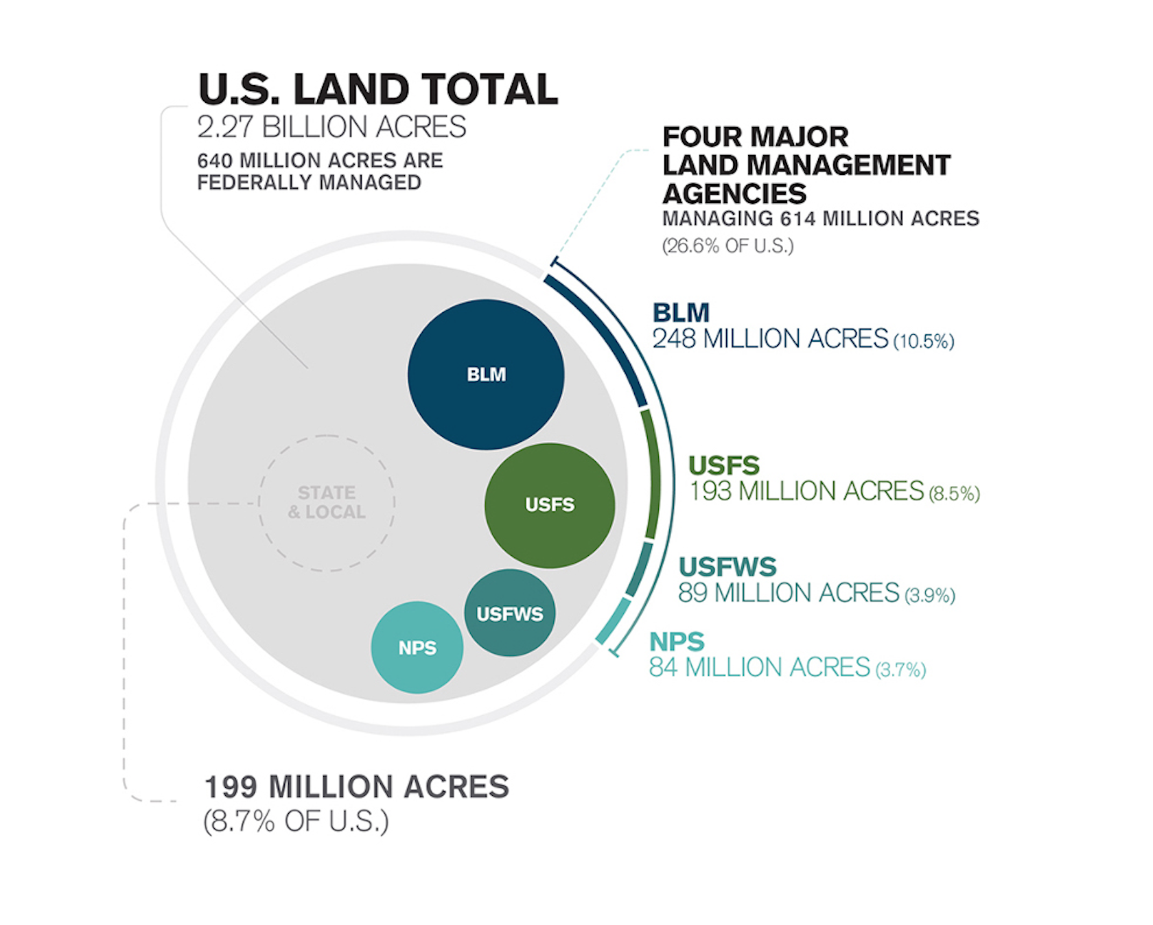
Okay, so now onto our Federal Public Lands. In the US we have four major land management agencies. They are the National Park Service, US Fish & Wildlife Service, US Forest Service, and the Bureau of Land Management. Together these four agencies make up for 614 million acres of public land.
The National Park Service is comprised of 62 National Parks and an additional 419 units that are managed by the National Park Service. Additional units include places such as National Monuments, National Battlefields, National Seashores, National Scenic Trails, National Recreation Areas, National Preserves, and National Historic Parks and Sites. In total there are 19 different naming designations that are also often referred to as ‘Parks’ but they are not technically National Parks. The National Park Service was created in 1916 by President Woodrow Wilson following the creation of the “Organic Act.” Parks can only be created by Congress with the purpose of protecting land for future generations, while still offering recreation for current generations. Fun fact, our newest National Park is White Sands National Park in New Mexico, which was formerly a National Monument.
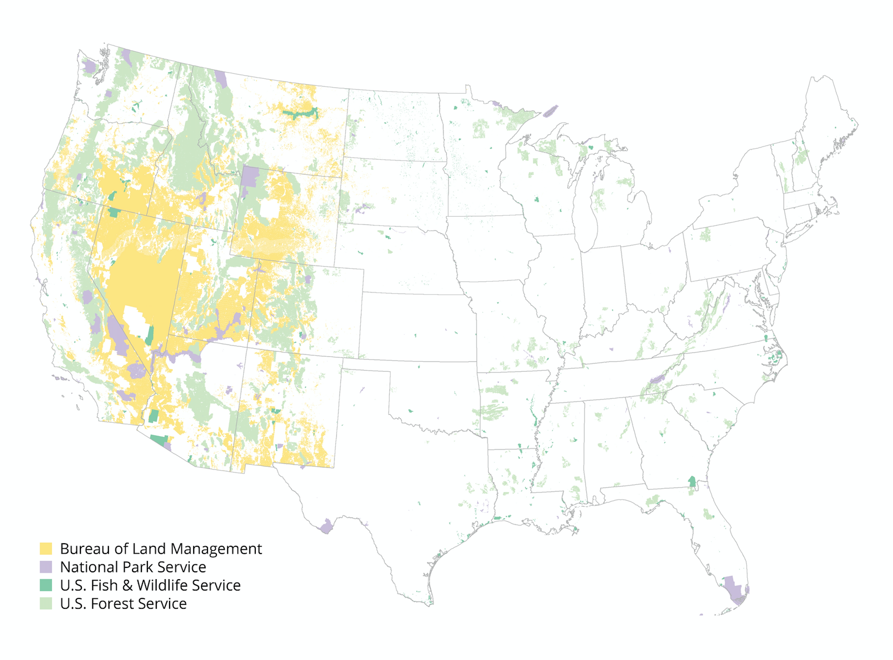
The US Fish & Wildlife Service holds 89 million acres of public land. The US Fish and Wildlife Service is the oldest of our federal conservation agencies. It was established back in 1871, and it is the only agency within the federal government whose primary responsibility is the management of fish and wildlife for the American public. The US Fish & Wildlife Service (USFS for short) manages a diverse network of lands and waters which include wetlands, fisheries, coastal areas, and Wildlife Refuges. If you are to ever visit a public lands area managed by the USFS, it would most likely be a Wildlife Refuge. The lands and waters that make up the National Wildlife Refuge System are designated in order serve the distinct purpose of wildlife conservation. Conservation drives all of the decision making for Wildlife Refuges, including what recreational activities are allowed and what resource management tools are used.
The US Forest Service manages our National Forests and Grasslands, as well as our Wild and Scenic Rivers, some Wilderness areas and 158,000 miles of trails. In total the US Forest Service (USFS for short) manages 193 million acres of public land. If you’re primarily a hiker, you have most likely hiked on trails that are within our National Forests. Our biggest and most popular National Forest areas would include places throughout the Northwest, California, and Colorado. National Forest areas are also tremendously popular on the East Coast, with notable areas being the White Mountains, and areas which contain the Appalachian Trail. At the heart of the US Forest Service is a management plan that they call “Caring for the Land and the Serving People.” The US Forest Service manages its lands for multiple uses which includes recreation, as well as vegetation and forest management. For those of us who have an interest in recreating, National Forests serve as an incredible space for hiking, backpacking, camping, hunting, and fishing. Of the 158,000 miles of trails, there are 98,279 miles of non-motorized use and Wilderness, and 60,223 miles of trails designated for motorized use.
The Bureau of Land Management has 248 million acres of public land. All BLM land is located in the Western States. Alaska, Arizona, California, Colorado, Idaho, Montana, Nevada, New Mexico, Oregon, Utah, Washington and Wyoming all have public lands that are managed by the BLM. The mission of the BLM is “to sustain the health, diversity, and productivity of the public lands for the use and enjoyment of present and future generations.” Much like the US Forest Service, the BLM also operates under a management plan that allows for multiple use. Popular uses of BLM land include hiking, biking, climbing, dispersed camping, hunting and fishing, rafting and kayaking, and ATV and OHV use. BLM land is often located near or around other more popular public lands, like the National Parks. The BLM also manages areas of Wilderness, Wild & Scenic Rivers, National Conservation Lands, and National Monuments. To find out where BLM land is near you or to explore a BLM land, visit the locations and services pages on the blm.gov website.
Infographic from Outdoor Alliance
In addition to local and federal public lands management, there are a few additional places that can be visited that I like to call the public lands wild cards. They are places and designations that are lesser known, and also places that maybe you haven’t heard of or been to.
A Public Lands Trust is a community based land conservancy. It is land that is privately owned and donated for the purpose of protection and stewardship. They are private lands for the public good. A Land Trust is accredited through the Land Trust Alliance. A Public Lands Trust does not necessarily mean that the land is open to the public, but some are. The appeal of a Land Trust is that the land is protected in perpetuity and cannot be developed. A Public Lands Trust that we know and love here in California is the Ventura Land Trust. The Ventura Land Trust envisions a Ventura with more trails, more hiking, more biking, and more opportunity to enjoy natural areas. “We envision a more preserved open space that balances the protection of wildlife and the environment. Working with willing landowners, land is either protected via acquisition or through a land conservation agreement.” To learn more about Land Trusts and the VLT, visit venturalandtrust.org.
Tribal Parks are lands that are managed by Native People “to better harmonize human needs and environmental well-being.” They are lands that belong to and are managed by the Tribes and we as the public are granted access there from the Tribes. It is important to note that our public lands, as noted throughout this article are Native (Indigenous) Lands. I hope that as you research and learn about these places, that you also learn about their indigenous history. Well known and popular Tribal Parks would be Monument Valley and Antelope Canyon. We also, in some places, have access to Reservation Lands that are open to the public. Havasupai is a Reservation Land, open to the public. If you are visiting there you are granted access via a permit system. Canyon De Chelly is a National Monument that is co-managed by the Tribes and the National Park Service. Remember that if you are visiting these places to visit them with respect and leave them better than you found them.
We have 43 National Recreation Areas in the US and each one of them is managed by a different federal agency. Most of these areas are managed by either the National Park Service or the Forest Service, and the BLM manages just one, the White Mountains in Alaska. Popular National Recreation Areas include Glen Canyon in Arizona, Mount Baker in Washington, the Golden Gate Bridge and the Delaware Water Gap. These areas have all different and wide ranging opportunities for recreation, each of which is dependent upon the place and land management agency. You’ll find everything from outdoor shooting ranges to paved walking trails at each of our National Recreation Areas.
A National Scenic Area is a designation that helps protect the scenic value of a federally managed public land. This designation is less stringent than that of a Wilderness designation while still offering protections and preservation. There are currently 10 National Scenic Areas in the US. Alabama Hills, a popular camping destination in the Eastern Sierra is the newest one, designated just last year in 2019.
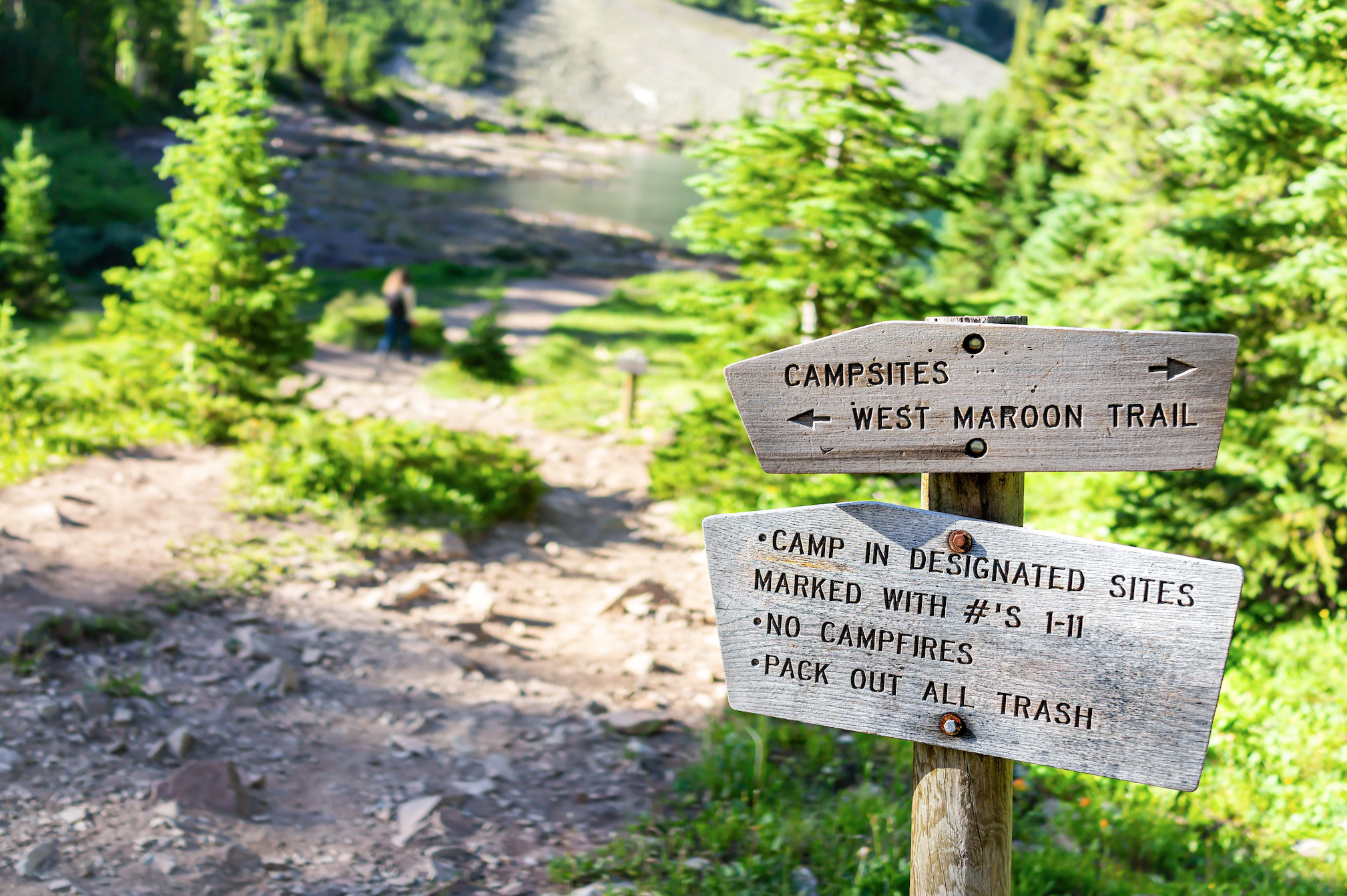
A Wilderness designation is the highest of level of protection that can be issued for a public lands area. Places of Wilderness are designated by Congress, and when that designation is received, that land becomes part of the National Wilderness Preservation System. This System was created by the Wilderness Act of 1964, signed into law by President Lyndon B Johnson. In essence, a Wilderness designation is a protective overlay that Congress applies to selected portions of National Forests, Parks, Wildlife Refuges, and other public lands. All four of our federal public lands agencies have, protect, and maintain areas of Wilderness. What is allowed in Wilderness? Just about any recreational pursuit is allowed in a Wilderness area minus the use of any mechanized vehicles. Hunting, fishing, climbing, camping, kayaking, canoeing, rafting, skiing, showshoeing… and more are all allowed in Wilderness areas. What is prohibited? Logging, mining, road-building and the use of any motorized or mechanized vehicles (including bikes). Pre-existing mining claims and grazing ranges are permitted through grandfather clauses in the Wilderness Act. Access to Wilderness is limited in some areas and requires a permit to access. Popular Wilderness areas include the John Muir Wilderness in California, the Boundary Waters in Minnesota, the Maroon Bells Snowmass in Colorado and the Pemigewasset Wilderness in New Hampshire. See a complete list of Wilderness Areas here.
There are 128 protected areas in the United States known as National Monuments. A National Monument can be established by Congress though legislation or by the President through the use of the Antiquities Act. The Antiquities Act gives the President the power to set aside objects and structures of historic and scientific interest as National Monuments. This designation, like Wilderness, is much like a protective overlay for an existing federal public land. A National Monuments can be managed by any of the four federal land management agencies, the National Park Service, US Forest Service, US Fish and Wildlife Service, or the Bureau of Land Management. Popular and well travelled to National Monuments include the Statue of Liberty, Mount Rushmore, and the Bears Ears and Grand Staircase Escalante National Monuments. See a complete list of National Monuments here.
Whether you’re using this resource to learn more about these places, or looking to find a place to hike near you, remember to check for closures and what resources are available for where you’re going. It is strongly suggested and recommended to stay at home, so if you’re headed out, stay local. Our local trails could also use some love right now, so maybe bring along a trash bag or Deuter dirtbag to pack out some trash. Remember to as always, follow the 7 Principles of Leave No Trace, and keep your recreation activities low risk.
This blog is written by Nicole Brown. Nicole is the founder of Women Who Hike, a community that unites women both on and off the trail. Women Who Hike is a Leave No Trace Community Partner, and Nicole is a Leave No Trace Master Educator who also advocates for the protection of public lands.
Visit the following pages for more information and resources specifically about how Covid-19 is affecting federal land management agencies and recreation sites: National Park Service, Forest Service, BLM, Fish and Wildlife Service, US Army Corps of Engineers


